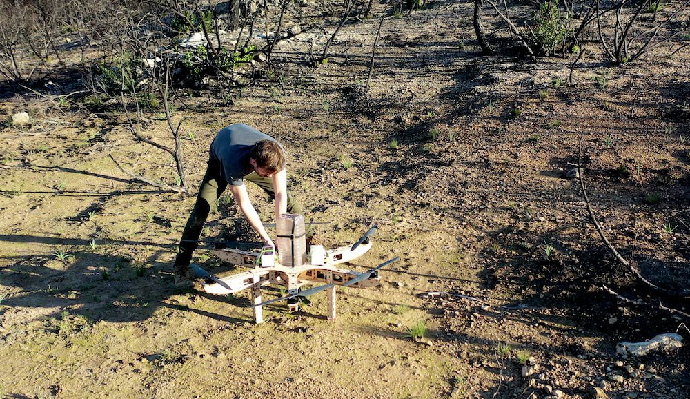

Picture a drone humming over a fire-scarred hillside. Instead of carrying a camera, a suspicious package, or somebody’s cold lunch, it carries thousands of native seeds. The aircraft follows a mapped route, reaches the target zone, opens its dispersal system, and sends seed capsules tumbling toward the earth. “Seeds away!” sounds like a line from an action movie, but it also captures one of the most intriguing ideas in modern ecological restoration: planting landscapes from the air.
The phrase “Approaching The Drop Location: Seeds Away!” became associated with Dronecoria, an open-source drone project designed for large-scale aerial sowing. Its goal was not to replace a gardener carefully planting a backyard maple. It was built for a much bigger job: distributing native seeds across burned forests, degraded grasslands, inaccessible slopes, and other places where conventional planting crews may struggle to work efficiently.
Aerial seeding is exciting because it combines robotics, geographic data, native plant science, and a dash of “let’s see whether this wooden flying machine can help rebuild an ecosystem.” Yet dropping seeds is only the opening scene. Successful restoration depends on what happens before the flight, where each seed lands, and whether anyone returns to measure the results.
What Is Dronecoria?
Dronecoria is an open-source platform developed to support aerial reforestation and ecological restoration. The project combines a heavy-lift multicopter, an automated flight controller, a seed hopper, and 3D-printable dispersal components. Its frame can be fabricated from laser-cut plywood, while design files are available for people who want to study, reproduce, or improve the system.
According to the project specifications, the aircraft was designed to carry as much as 10 kilograms of seed material. Its creators estimated that it could autonomously sow roughly one hectare in about 10 minutes while traveling at approximately five meters per second. Those figures are project claims rather than a universal guarantee; real coverage depends on seed size, terrain, wind, battery performance, flight restrictions, and the desired distribution rate.
The project’s most valuable idea may be its openness. Dronecoria treats restoration technology as something ecologists, engineers, fabricators, students, and community organizations can examine together. Instead of locking every component behind a proprietary wall, it encourages adaptationwith proper attribution and responsible testing.
How Aerial Seeding Works
Aerial seeding means distributing seed from an aircraft, which may be a fixed-wing airplane, helicopter, or uncrewed aerial vehicle. The method has long been used for grasses, rangeland rehabilitation, post-fire stabilization, and agricultural cover crops. Drones add finer navigation, lower-altitude operation, detailed mapping, and the potential for targeted releases.
1. Surveying the restoration site
The operation should begin with ecology, not propellers. Specialists examine burn severity, soil condition, existing vegetation, slope, erosion risk, invasive species, drainage patterns, and evidence of natural regeneration. Drone imagery, satellite data, topographic maps, and ground surveys can help identify areas that genuinely need intervention.
This step prevents a surprisingly common mistake: treating an entire landscape as equally damaged. One section may need seeding, another may recover naturally, and a third may require invasive-plant control before any native seed has a reasonable chance of survival.
2. Selecting appropriate native seeds
The seed mix must match the ecosystem. A restoration plan may combine trees, shrubs, grasses, and flowering plants rather than relying on a single charismatic species. Diversity can support soil stability, pollinators, wildlife habitat, and ecological resilience.
Local adaptation matters as well. Plants from one climate or elevation may perform poorly when transferred to a very different environment. U.S. restoration agencies use seed zones and other sourcing tools to identify plant materials suited to local or projected conditions. Dropping “some seeds that looked outdoorsy” is not a restoration strategy.
3. Preparing seeds or protective capsules
Some systems broadcast loose seed, while others use pellets or capsules. A seed capsule may include clay, compost, fibers, minerals, beneficial microorganisms, or moisture-retaining ingredients. The purpose is to protect the seed, improve handling, reduce wind drift, and create a more favorable germination environment.
Capsules are not magical life-support pods, however. A coating cannot compensate for the wrong species, severe drought, deep shade, aggressive weeds, or a landing spot on solid rock. It can improve the odds, but nature still reviews every application.
4. Programming the flight and drop pattern
Operators create a flight plan based on the target area, aircraft endurance, release width, terrain, obstacles, and required seed density. The drone can then follow parallel passes or more customized paths while the hopper releases material at calibrated intervals.
A uniform grid may be useful for agricultural cover crops, but ecological restoration often benefits from more nuanced placement. Algorithms can prioritize depressions, exposed mineral soil, sheltered microsites, or zones with suitable moisture. Precision matters because the “drop location” can determine whether a seed becomes a plant or an expensive snack for a mouse.
5. Monitoring germination and survival
A flight log proves only that seeds left the aircraft. It does not prove that a forest is growing. Restoration teams must return to measure germination, seedling survival, species composition, invasive-plant pressure, soil stability, and changes over multiple seasons.
Drones can assist again by collecting repeat imagery, but field sampling remains important. A green patch viewed from the air might contain the desired native grassor an invasive weed celebrating its unexpected real estate opportunity.
Why Drop Seeds From the Sky?
Faster access to large landscapes
Aircraft can distribute material over areas that would require days or weeks of hiking. Drones are particularly attractive for rugged slopes, unstable burn scars, remote watersheds, wetlands, mine sites, and locations where conventional machinery would damage the soil.
Reduced exposure to dangerous terrain
Post-fire landscapes can contain falling trees, unstable slopes, loose rocks, ash pits, and damaged roads. Using an aerial platform may reduce the amount of time workers must spend in hazardous areas, although crews are still needed for planning, loading, maintenance, observation, and monitoring.
More precise deployment
Compared with broad releases from conventional aircraft, a drone can fly closer to the terrain and follow detailed digital routes. Sensors and mapping software may help operators change application rates, avoid sensitive areas, and concentrate seeds in higher-potential microsites.
Rapid post-disturbance response
After wildfire, land managers sometimes need to stabilize soil, limit erosion, suppress invasive plants, or restore priority habitat. For example, the Bureau of Land Management has used aerial seeding to distribute locally sourced sagebrush seed over thousands of acres selected through post-fire assessment. The technique is chosen according to terrain, accessibility, ecological priorities, and the condition of each sitenot simply because drones look impressive in promotional videos.
The Hard Truth: “Seeds Away” Does Not Mean “Trees Guaranteed”
Aerial seeding is often described with breathtaking production numbers: seeds per minute, acres per day, or capsules per flight. Those numbers measure deployment. Restoration success must be measured in established plants, functioning habitat, and long-term ecological recovery.
Seed-to-soil contact
Broadcast seed commonly remains on the surface. If it lands on thick litter, dense vegetation, hard crust, or exposed stone, it may never reach a suitable germination site. Rough, moist, friable soil generally provides better opportunities for seeds to settle and contact the ground.
Moisture and timing
Seeds need suitable moisture during germination and early root development. USDA guidance for aerially seeded cover crops emphasizes the importance of moisture near the soil surface at seeding time or soon afterward. A perfectly planned drop followed by several weeks of dry weather can produce a beautifully mapped disappointment.
Predation and environmental stress
Birds, rodents, insects, and other animals may consume exposed seeds. Those that germinate still face frost, heat, drought, competition, disease, and herbivory. Recent research discussions have noted very low survival in some drone-seeding trials, demonstrating why deployment totals should never be presented as established-tree totals.
Competition from invasive plants
Fast-growing invasive species may capture water, sunlight, and nutrients before native seedlings become established. Site preparation may therefore be more important than the seeding flight itself. Restoration practitioners often combine weed control, prescribed fire, mechanical treatment, mulching, soil-surface modification, or carefully timed planting with seed distribution.
Limited supplies of appropriate seed
Native seed is a valuable and sometimes scarce resource. Collecting wild seed, preserving genetic diversity, cleaning it, testing it, increasing supply through growers, storing it, and delivering it at the correct time require an entire supply chain. A machine capable of dropping millions of seeds is not especially helpful when the ecologically appropriate seed is unavailable.
A Drone Is a Tool, Not an Ecologist
The aircraft can carry seeds and follow coordinates, but it cannot independently decide what a healthy local ecosystem should become. Those decisions require botanists, foresters, soil specialists, wildlife experts, Indigenous knowledge holders, land managers, regulators, and local communities.
A responsible project begins with a reference ecosystem and measurable objectives. Is the goal to control erosion, restore a native grassland, establish pollinator habitat, rebuild a mixed forest, or reconnect wildlife corridors? Each goal requires a different seed mix, schedule, site treatment, and monitoring plan.
Introducing the wrong species can create ecological problems rather than solve them. Even native species must be evaluated for genetic suitability, abundance, functional role, and likely performance under changing environmental conditions. Restoration is not confetti with photosynthesis.
Engineering Challenges Behind the Seed Drop
Payload versus flight time
Every pound of seed reduces endurance and changes aircraft handling. Engineers must balance hopper capacity, battery weight, structural strength, motor efficiency, and reserve power. A system should never be operated at the edge of its theoretical capability merely to advertise a larger payload.
Consistent seed flow
Seeds vary enormously in size, shape, texture, and density. Some roll like tiny beads; others have wings, hairs, hooks, or fluffy structures that clog a hopper at the first opportunity. A disperser must prevent bridging, crushing, overfeeding, and irregular flow.
Calibration
Before a real mission, operators should test the release system with safe material over a measured area. They can then compare the expected and actual application rates, check swath width, evaluate wind movement, and adjust the gate opening or disperser speed.
Navigation and terrain following
Slopes, trees, utility lines, communication loss, magnetic interference, and changing elevation complicate autonomous flight. Terrain data must be accurate, and the operation needs emergency procedures for loss of positioning, motor failure, low battery, unexpected people, or rapidly changing weather.
Legal and safety requirements
In the United States, nonrecreational small-drone operations generally fall under FAA rules. External loads must be securely attached and must not compromise controllability. More complex flights, heavier aircraft, beyond-visual-line-of-sight operations, or certain dispensing activities may require additional certification, exemptions, or waivers. Operators must determine which rules apply before loading a hopper and shouting anything dramatic.
Where Aerial Seeding Makes Senseand Where It Does Not
| Promising Applications | Situations Requiring Another Approach |
|---|---|
| Remote or hazardous terrain | Sites needing deep seed placement |
| Large post-fire rehabilitation areas | Land with dense invasive vegetation |
| Grassland and wildflower restoration | Extremely dry sites without expected rainfall |
| Cover crops in suitable agricultural systems | Small, accessible plots better planted by hand |
| Testing multiple targeted seed treatments | Projects lacking appropriate native seed |
| Hybrid restoration with ground crews | Areas where natural regeneration is already strong |
The most effective strategy is often hybrid. Drones can distribute grasses, shrubs, or tree seeds across suitable areas while crews plant nursery-grown seedlings in priority microsites. Ground teams can also prepare soil, remove invasive plants, protect young vegetation, and verify results.
How to Plan a Responsible Aerial-Seeding Mission
- Define ecological objectives. Specify the desired plant community and measurable outcomes.
- Conduct site assessments. Evaluate soil, moisture, competing vegetation, natural regeneration, wildlife, and access.
- Select suitable native materials. Use appropriate species, seed zones, and genetic diversity.
- Prepare the site. Address invasive plants, surface crust, erosion, or thick litter when necessary.
- Choose a deployment method. Compare loose seed, coated seed, pellets, hand planting, drilling, and nursery stock.
- Calibrate and test safely. Confirm distribution rate, flight stability, release timing, and emergency procedures.
- Match the flight to weather. Consider wind, rainfall forecasts, temperature, and soil moisture.
- Monitor for several seasons. Measure establishment, survival, diversity, invasive species, and soil response.
A Day Near the Drop Location: A Composite Field Experience
The following account is a composite illustration based on common restoration workflows, not a claim of personal participation in one specific mission.
The field day begins before sunrise because the wind has not yet remembered that it enjoys ruining carefully planned drone operations. The restoration team parks near the boundary of a burned hillside and unloads batteries, tools, radios, seed containers, safety equipment, and enough checklists to make a clipboard nervous.
The site does not resemble a blank canvas. Blackened tree trunks remain standing. Native shrubs are resprouting in scattered pockets, invasive grasses occupy several sunny areas, and erosion channels cut across the lower slope. The ecological lead reviews the treatment map and removes two zones from the flight plan because natural regeneration there is stronger than expected. Saving seed is not a disappointment; it is evidence that the land is already doing part of the job.
Technicians inspect the aircraft, motors, propellers, fasteners, wiring, batteries, flight controller, hopper gate, and emergency controls. The seed mix contains locally appropriate grasses, flowering plants, and shrubs selected for different ecological functions. Some species establish quickly and protect the soil. Others provide longer-term structure, seasonal flowers, or food for wildlife.
A calibration test reveals that the first hopper setting releases too much material. Without that test, the aircraft would exhaust its payload halfway through the planned route and create one extremely well-seeded patch surrounded by disappointed acreage. The team reduces the opening, repeats the test, and records the new application rate.
The pilot announces the launch. The drone rises under the combined weight of batteries, hardware, and thousands of tiny biological possibilities. It follows the hillside rather than flying at one fixed elevation. At the first target line, the disperser activates. Capsules fall in a controlled stream, bounce against bare soil, disappear into cracks, and settle beside branches and rocks.
From a distance, the operation looks effortless. Up close, everyone watches battery voltage, wind direction, aircraft position, seed flow, nearby birds, and the possibility that a curious hiker may wander into the work area. The drone returns with a safe reserve, lands, and receives another battery and payload.
By late morning, the wind strengthens. The team pauses rather than forcing the schedule. Small seeds are easily carried away from their intended swath, and precise restoration should not become an accidental donation to the neighboring watershed. The delay is inconvenient, but good fieldwork contains many moments when the correct decision is to stop doing something.
Several weeks later, rainfall activates the first wave of germination. Some plots show promising green cover, while others remain sparse. Monitoring crews place sampling frames, count seedlings, photograph fixed points, and record invasive plants. They discover that shaded microsites near woody debris outperform exposed ground. That information becomes part of the next mission plan.
Months later, the project cannot honestly claim that every dropped seed became a plant. Many did not. Yet the successful seedlings are reducing bare soil, increasing plant diversity, and helping the site move toward recovery. The greatest achievement is not a flashy flight video. It is a better understanding of where, when, and how aerial seeding contributes to restoration.
Conclusion: The Future of “Seeds Away”
Dronecoria and similar aerial-seeding systems represent a compelling partnership between open-source engineering and ecological restoration. They can move seed across large or difficult landscapes, reduce human exposure to hazardous terrain, and collect valuable spatial data. They can also fail spectacularly when deployment speed is treated as a substitute for ecological planning.
The future of drone reforestation will depend less on how many capsules an aircraft can release and more on how intelligently each mission is designed. Better mapping, native seed supply, biologically inspired coatings, microsite targeting, transparent survival data, and long-term monitoring may turn aerial seeding from a dramatic experiment into a dependable restoration tool.
So, when the aircraft approaches the drop location and the operator announces, “Seeds away,” the mission is not ending. It is only beginning. The real work continues in the soil, through changing weather, across growing seasons, and in every careful measurement that reveals whether those falling seeds are becoming a functioning ecosystem.


